1. Intent: The City recognizes the need to provide for rural residential and agricultural uses. Therefore the intent of this district is to provide opportunities for agriculture uses that promote the family farm and development of rural areas.
2. Permitted Uses: General agricultural and rural uses are allowed along with related public and semi-public uses. For a general listing of permitted and conditionally permitted uses by North American Industry Classification System (NAICS) groupings, see Appendix “A” of these regulations. The permitted uses will be determined based on compatibility with other uses permitted in the district and with the listed NAICS groupings in Appendix “A”
3. Special Uses: For a general listing of special uses, see Appendix “A”.
4. Intensity of Use Regulations:
A. Minimum or tract lot area: 10 acres
B. Minimum lot or tract width; 300 feet measured at the front setback line.
C. Minimum width to maximum depth ration = 1:4
5. Height Regulations: No main structure shall exceed forty (40’) feet in height.
6. Yard Regulations:
A. Front Yard: The front yard shall be a minimum of fifty (50’) feet in depth measured from the front property line or, on collector streets, measured ninety-five (95’) feet from the centerline of the street or, on arterial streets, measured one hundred five (105’) feet from the centerline of the street, whichever front yard setback would be greater.
B. Side Yard: There shall be a side yard on each side of every single-family dwelling which shall be not less than fifty (50’) feet in width for all uses. Corner lots or tracts shall provide a fifty (50’) foot setback from the corner side yard.
C. Rear Yard: There shall be a rear yard of not less than fifty (50’) feet.
D. Minimum Floor Area: 1,100 square feet of habitable floor area per family.
1. Intent: It is the intent of the “R-0” Residential Suburban District to control subdivision and density of development of land for residential and other non-commercial uses for suburban design purposes; and where such uses are not or cannot be connected to a public sewer supply.
2. Permitted Uses: Single-family residences, certain group living uses and related public and semi-public uses are permitted. For a general listing of permitted and conditionally permitted uses by North American Industry Classification System (NAICS) groupings, see Appendix “A” of these regulations. The permitted uses will be determined based on compatibility with other uses permitted in the district and with listed NAICS groupings in Appendix “A”. (Ord. 2108)
3. Special Uses: For a general listing of special uses, see Appendix “A”.
4. Intensity of Use Regulations: Except as hereinafter provided, all dwellings hereafter erected, enlarged, or reconstructed shall be located upon lots or tracts containing the following areas:
A. Every lot or tract served with public sanitary sewers and public water system shall have an area of not less than 12,000 square feet and a lot width of not less than 100 feet measured at the front setback line. (Corner lots or tracts shall not be less than 120 feet in width.)
B. Every lot or tract not served with a public sanitary sewer shall have an area not less than required by the City of De Soto Subdivision Regulations, and shall be subject to on-site wastewater testing.
5. Height Regulations: No structure shall exceed 35 feet in height, except that public and semi-public structures, public service and institutional structures, hospitals, schools, and religious institutional structures are permitted two feet of additional height for each one foot of additional structure setback.
6. Yard Regulations:
A. Front Yard: The front yard shall be a minimum of 50 feet in depth measured from the front property line or, on collector streets, measured 95 feet from the centerline of the street or, on arterial streets, measured 105 feet from the centerline of the street, whichever front yard setback would be greater.
B. Side Yard: There shall be a side yard on each side of every single-family dwelling which shall be not less than 15 feet in width, and all other permitted and special uses shall provide a 50-foot side yard. Corner lots or tracts shall provide a 50-foot setback from the corner side yard.
C. Rear Yard: There shall be a rear yard of not less than 30 feet.
D. Minimum Floor Area: 1,100 square feet of habitable floor area per family.
E. Setbacks Specific to Accessory Structures: 50 feet for Front Yard, 30 feet for Rear Yard, and 15 feet for Side Yard
1. Intent: The intent of this district is to provide for low density residential development including those uses which reinforce residential neighborhoods.
2. Permitted Uses: Generally, single-family dwellings, parks, educational and religious uses are permitted. For a general listing of permitted and conditionally permitted uses by North American Industry Classification System (NAICS) groupings, see Appendix “A” of these regulations. The permitted uses will be determined based on compatibility with other uses permitted in the district and with listed NAICS groupings in the Appendix “A”. (Ord. 2108)
3. Special Uses: For a general listing of special uses, see Appendix “A”.
4. Intensity of Use Regulations: Except as modified by the provisions of Article 5:
A. Minimum Lot or Tract Area: 10,350 square feet.
B. Minimum Lot or Ttract Width: 90 feet measured at the front setback line.
C. Lot or Tract Coverage: Principal and accessory structures shall not cover more than 30 percent of the lot or tract.
5. Height Regulations: Maximum Structure Height: 35 feet.
6. Yard Regulations:
A. Front Yard: 35 feet.
B. Side Yard: Ten percent of the lot or tract width, except that such side yard shall not be less than 10 feet and need not be more than 15 feet. Structures on corner lots or tracts shall provide a side yard on the street side of not less than 20 feet, or the established front yard setback of any neighboring residential structure fronting on the side street whichever is greater.
C. Rear Yard: 30 feet.
7. Use Limitations:
A. Minimum Floor Area: 1,100 square feet of habitable floor area per family.
1. Intent: The intent of this district is to provide for moderate density residential development, including moderate density single-family dwellings, in a manner that will encourage a strong residential neighborhood that provides a variety of housing types, preserve natural features within the community including existing high-quality vegetation and water features, promotes active and passive recreation opportunities, and promotes compatibility with neighboring uses.
2. Permitted Uses: Generally, single-family dwellings, parks, educational and religious uses are permitted. For a general listing of permitted and conditionally permitted uses by North American Industry Classification System (NAICS) groupings, see Appendix “A” of these regulations. The permitted uses will be determined based on compatibility with other uses permitted in the district and with listed NAICS groupings in the Appendix “A”. (Ord. 2108)
3. Special Uses: For a general listing of special uses, see Appendix “A”.
4. Intensity of Use Regulations: Except as modified by the provisions of Article 5:
A. Minimum Lot/Tract Area:
Single-family - 6,000 square feet. If the open space dedication is utilized the minimum lot size can be reduced to 5,500 square feet and front and rear set back reduced 5’ each.
Other uses - 7,500 square feet.
B. Minimum Lot/Tract Width: 50 feet measured at the front setback line, except as provided in Article 5, Section 2 Yard Regulations.
C. Lot/Tract Coverage: Principal and accessory structures shall not cover more than 40 percent of the lot/tract.
5. Height Regulations: Maximum Structure Height: 35 feet.
6. Yard Regulations: Except as modified by the provisions of Article 5, minimum yard depths shall be as follows:
A. Front Yard: 25 feet.
B. Side Yard: 5 feet, except as provided in Article 5, Section 2, Yard Regulations.
C. Rear Yard: 20 feet.
7. Use Limitations:
A. Minimum Floor Area: 1,100 square feet of habitable floor area per family.
B. Open Space: All R-1A subdivisions larger than two (2) acres shall dedicate a minimum of ten (10) percent of the gross area to be subdivided with private open space to include a dedicated amenity or recreational feature. Stormwater detention can be included in the open space calculation. The dedicated amenity or recreational feature located on stormwater detention tract(s) shall be located outside the stormwater detention storage/basin area. Unless otherwise excepted by the City Council, all private open space shall be included in restrictive covenants, easements, or other legal devices designated to assure that such space will remain permanently open and perpetually maintained.
(Ord. 2107; Ord. 2644)
1. Intent: The intent of this district is to provide for moderat1e density residential development, including two-family and higher density single-family dwellings, in a manner that will encourage a strong residential neighborhood.
2. Permitted Uses: Generally, single-family dwellings, two-family dwellings, selected Group Living uses, parks, educational and religious uses are permitted. For a general listing of permitted and conditionally permitted uses by North American Industry Classification System (NAICS) groupings, see Appendix “A” of these regulations. The permitted uses will be determined based on compatibility with other uses permitted in the district and with listed NAICS groupings in the Appendix “A”. (Ord. 2108)
3. Special Uses: For a general listing of special uses, see Appendix “A”.
4. Intensity of Use Regulations: Except as modified by the provisions of Article 5:
A. Minimum Lot or Tract Area:
Single-family dwelling 6,000 sf for single family
Two-family dwelling 7,200 sf for two family
Other uses 7,500 square feet.
B. Minimum Lot or Tract Width:
Single Family - 50’ measured at the front setback line.
Two family - 60 feet measured at the front setback line, except as provided in Article 5, Section 2 Yard Regulations.
C. Lot or Tract Coverage: Principal and accessory structures shall not cover more than 40 percent of the lot or tract.
5. Height Regulations: Maximum Structure Height: 35 feet.
6. Yard Regulations: Except as modified by the provisions of Article 5, minimum yard depths shall be as follows:
A. Front Yard: 25 feet.
B. Side Yard: 5 feet, except as provided in Article 5, 2, Yard Regulations.
C. Rear Yard: 20 feet.
7. Use Limitations:
A. Minimum Floor Area: 1,100 square feet of habitable floor area per family.
(Ord. 2629)
1. Intent: The intent of this district is to provide for moderate density residential development, including two, three, and four-family dwellings, in a manner that will encourage a strong residential neighborhood.
2. Permitted Uses: Generally, two, three, and four-family dwellings; selected Group Living uses; parks; educational and religious uses are permitted. For a general listing of permitted and conditionally permitted uses by North American Industry Classification System (NAICS) groupings, see Appendix “A” of these regulations. The permitted uses will be determined based on compatibility with other uses permitted in the district and with listed NAICS groupings in the Appendix “A”. (Ord. 2108)
3. Special Uses: For a general listing of special uses, see Appendix “A”.
4. Intensity of Use Regulations: Except as modified by the provisions of Article 5:
A. Minimum Lot or Tract Area: Subject to Site Plan Review.
B. Minimum Lot or Tract Width: Subject to Site Plan Review
C. Lot or Tract Coverage: Principal and accessory structures shall not cover more than 40 percent of the lot or tract.
5. Height Regulations: Maximum Structure Height: 35 feet.
6. Yard Regulations: Except as modified by the provisions of Article 5, minimum yard depths shall be as follows:
A. Front Yard: 25 feet.
B. Side Yard: 7 feet, except as provided in Article 5, 2, Yard Regulations.
C. Rear Yard: 20 feet.
(Ord. 2397)
1. Intent and Purpose of District: The “R-3” Multifamily Dwelling District is intended for the purpose of allowing high residential density land use with the co-mingling of compatible single-family and two-family dwellings, apartments, home occupations, community facilities and certain uses, yet retain the basic residential quality.
2. Permitted Uses: Single-, two-, and multi-family dwellings, and selected Group Living uses are permitted. For a general listing of permitted and conditionally permitted uses by North American Industry Classification System (NAICS) groupings, see Appendix “A” of these regulations. The permitted uses will be determined based on compatibility with other uses permitted in the district and with listed NAICS groupings in the Appendix “A”. (Ord. 2108)
3. Special Uses: For a general listing of special uses, see Appendix “A”.
4. Intensity of Use Regulations: Except as hereinafter provided, all dwellings hereafter erected, enlarged, relocated, or reconstructed shall be located upon lots or tracts containing the following areas:
A. A lot or tract on which there is erected a single-family dwelling shall contain an area of not less than 6,000 square feet. No lot or tract shall be less than 50 feet in width; corner lots/tracts shall be not less than 60 feet in width.
B. A lot or tract on which there is erected a two-family dwelling shall contain an area of not less than 7,200 square feet per dwelling unit. No lot or tract shall be less than 60 feet in width; corner lots/tracts shall be not less than 70 feet in width.
C. A lot or tract on which there is erected a multifamily dwelling shall have a maximum density of 24 dwelling units per acre (approximately 1,815 square feet per unit). This regulation shall not apply to allowed Group Living uses where no cooking is done in individual rooms or apartments.
D. Where a single lot or tract of record, as defined in the definitions section of this regulation, has less area than herein required and was recorded prior to November 16, 1978, when the City first established subdivision regulations or prior to annexation of such land into the City of De Soto, that lot may be used only for single-family dwelling purposes.
E. Multifamily uses shall not cover more than 40 percent of the lot or tract area.
5. Height Requirements: No structure shall exceed 45 feet in height, except that for each one foot of additional front yard provided, two additional feet of height will be permitted.
6. Yard Requirements:
A. Front Yard:
(1) The front yard shall be a minimum of 25 feet in depth measured from the front property line; or on collector streets 70 feet measured from the centerline of the street; or on arterial streets 80 feet measured from the centerline of the street, whichever front yard setback would be greater.
(2) Where a lot(s) or tract(s) have double frontage, the required front yard shall be provided on both streets.
(3) Where a lot or tract is located at the intersection of two or more streets, there shall be a front yard on each street side of the corner lot or tract, except the buildable width of such lot or tract shall not be reduced to less than 35 feet. No accessory structure shall project beyond the front yard line of either street.
B. Side Yard:
(1) There shall be a side yard on each side of a structure 35 feet high or less having a width of not less than five feet.
(2) There shall be a side yard having a width of not less than ten feet on each side of a structure in excess of 35 feet in height.
C. Rear Yard: There shall be a rear yard for structures in this district which shall have a depth of not less than 20 feet, or 20 percent of the depth of the lot or tract, whichever is smaller.
7. Loading and Unloading Regulations: See the article on Parking and Loading Regulations.
8. Parking Regulations: Off-street parking is not required in this district for existing residential structures. Any new structures, and any structure converted to multifamily dwelling units, shall comply with the requirements of the article on Parking and Loading Regulations.
9. Sign Regulations: See the article on Sign Regulations.
10. Use Limitations:
A. Development in the “R-3” District shall be subject to site plan review requirements and procedures, and the Multi-Family Design Guidelines as applicable.
(Ord. 2564; Ord. 2629)
1. Intent: The intent of this district is to allow for moderate density residential development, including two-family and higher density single-family dwellings, in a manner that encourages a strong residential neighborhood consistent with the traditional character of “old-town” De Soto.
2. Permitted Uses: Generally, single-family dwellings, two-family dwellings, selected Group Living uses, parks, educational and religious uses are permitted. For a general listing of permitted and conditionally permitted uses by North American Industry Classification System (NAICS) groupings, see Appendix “A” of these regulations. The permitted uses will be determined based on compatibility with other uses permitted in the district and with the listed NAICS groupings in Appendix “A”. (Ord. 2108)
3. Special Uses: For a general listing of special uses, see Appendix “A”.
4. Intensity of Use Regulations: Except as modified by the provisions of Article 5:
A. Minimum Lot or Tract Area:
Single-family dwellings-
5,000 square feet for buildable lots or tracts established prior to April 16, 1998.
7,500 square feet for buildable lots or tracts established after April 16, 1998.
Two-family dwellings - 4,000 square feet/dwelling unit.
Other uses - 7,500 square feet.
B. Minimum Lot or Tract Width: As measured at the front setback line, minimum width shall measure 50 feet for buildable lots or tracts established prior to April 16, 1998 and 65 feet for buildable lots or tracts established after April 16, 1998, except as provided in Article 5, Section 2 Yard Regulations.
C. Lot or Tract Coverage: Principal and accessory structures shall not cover more than 30 percent of the lot or tract.
5. Height Regulations: Maximum Structure Height: 35 feet.
6. Yard Regulations: Except as modified by the provisions of Article 5, minimum yard depths shall be as follows:
A. Front Yard: 25 feet, except that where a structure is to be erected on a lot or tract that is within 100 feet of existing structures on both sides, the minimum front yard setback shall be the average of the measurements from the edge of pavement of the street on which the structures front to the closest front corners of each adjacent structure. If the structure to be erected is within 100 feet of an existing structure on one side only, such structure may be erected as close to the street as the existing adjacent structure. In addition, for the purposes of establishing the building lines for construction of entrance steps that are no higher than 3’ from grade level or of any handicap access ramp or chair lift, the required front yard setback shall not apply. In no event shall any construction extend into any public right-of-way.
B. Side Yard: 7 feet.
C. Rear Yard: 20 feet, except that where a structure is to be erected on a lot or tract that has a rear yard abutting an alley, the minimum rear yard setback shall be 5 feet. For the purposes of this section, an alley shall be defined as a public right-of-way designed to provide vehicular access to the rear of those properties whose principal frontage is on a public street.
D. Existing Nonconforming Structures: In addition to those allowances of Article 9, Section 2 Non-Conforming Lots or Tracts of Record, residential dwellings and accessory structures to be reconstructed in the “R-H” district which are located on a lot or tract that does not comply with the above mentioned applicable yard regulations, with the exception of mobile homes, may be reconstructed to the previous setbacks, provided such reconstruction shall not create any additional nonconformity or increase the degree of existing nonconformity. In no event shall any construction extend into any public right-of-way.
7. Use Limitations:
A. Prior to issuance of a building permit, all new and redeveloped structures in the “R-H” District shall be subject to review by the city planner, city engineer and other staff as applicable according to the following guidelines:
(1) Front Entry: Entries and walkways should address the street directly, or in a manner consistent with adjacent properties.
(2) Building Orientation: New construction should address the street in a manner consistent with surrounding buildings. In most cases, building facades should be parallel to the street.
(3) Parking/Garage Location: Garages should be located and accessed at the rear or side of buildings via an alley or street access drive in order to maintain the residential and pedestrian character of the street. Further, parking located behind new residential dwellings which maintains the pedestrian character, and prevents automobiles from dominating the streetscape is encouraged. On-street parking is strongly discouraged. See Article 6, 3, H for parking facilities requirements.
(4) Heating, Ventilation, and Air Conditioning (HVAC) Equipment: HVAC equipment should be located at the rear of buildings, and screened from adjacent properties.
(5) Scale and Proportion: New and redeveloped dwellings should use appropriately scaled building mass, height and entry size, and incorporate architectural features such as gables, porches and windows to complement the surrounding buildings while breaking up the structure’s street facade.
(6) Rooflines and Pitch: Rooflines and pitch similar to surrounding structures are encouraged, as the similarity establishes a pleasing pattern and rhythm for the streetscape, allowing new construction to blend with the established neighborhood.
(7) Landscaping: Front facades (both yards in the case of corner lots/tracts) should be landscaped in a manner consistent with surrounding buildings. In addition, new and redeveloped dwellings should maintain the established streetscape by preserving existing or establishing new street trees and providing landscaping that is consistent with the pattern established by surrounding buildings.
(8) Appeals and Grievances: In the case an applicant should disagree or have other grievances with staff in the application of the above standards, the applicant should be directed to formally appear before the planning commission for review of such disagreement or other grievance.
B. Minimum Floor Area: The following floor area requirements apply, depending on the structure and living unit:
(1) Single Family Structure: 1,100 square feet of habitable floor area.
(2) Two Family Structure: 1,100 square feet of habitable floor area for each family unit, except the square feet may be reduced upon Planning Commission approval of a site plan submitted in accordance with Article 11 of the City Zoning Regulations.
(3) Reconstruction: If a structure was in existence and used as a residence prior to April 16, 1998, it may be reconstructed to no less than the floor area in existence prior to reconstruction of such structure so long as said floor area is at least 900 feet per family unit.
(Ord. 2373; Ord. 2398; Ord. 2428)
1. Intent: The intent of this district is to provide a zone which will accommodate the broad range of retail shopping activities, office uses and complimentary residential uses that are normally found in the core area of a city; and where development is allowed up to the property lot line, with no off-street parking facilities required of the private development. (Ord. 1144)
2. Permitted Uses: Generally, retail uses with no outdoor storage are permitted. For a general listing of permitted and conditionally permitted uses by North American Industry Classification System (NAICS) groupings, see Appendix “A” of these regulations. The permitted uses will be determined based on compatibility with other uses permitted in the district and with listed NAICS groupings in the Appendix “A”. (Ord. 2108)
3. Special Uses: For a general listing of special use permit uses (SUP), see Appendix “A”.
4. Intensity of Use Regulations:
A. Minimum Lot Area: None.
B. Minimum Lot Width: None.
5. Height Regulations: Maximum structure height: 100 feet.
6. Yard Regulations:
A. Minimum Front Yard: None.
B. Minimum Side Yard: None.
C. Minimum Rear Yard: 20 feet when adjacent to a residential district; otherwise, none.
7. Use Limitations:
A. No outdoor storage, except the display of merchandise for sale to the public, shall be permitted. Any merchandise stored outside which is determined by the Planning and Zoning Department as material which is not for sale to the public shall be screened or enclosed to the extent that it cannot be seen from off the property.
B. Outdoor seating may be allowed within City rights-of-way by Temporary Use Permit, see Article 5, Section 8 of these regulations. (Ord. 2107)
C. Exterior lighting fixtures shall be shaded so that no direct light is cast upon any residential property and so that no glare is visible to any traffic on any public street.
D. Residential uses in the “C-1” district shall be subject to the following additional use limitations: (Ord. 2107)
(1) Residential uses shall be complementary and secondary to the primary retail commercial and office uses of the central business district.
(2) Residential uses shall be restricted from street-level building floors except as permitted through a SUP. In no case shall a residential use occupy a street-level storefront.
(3) Residential uses shall not restrict or limit hours of operation, parking, loading, unloading, trash disposal or other activities associated with the commercial or office uses in the central business district.
(4) Parking for residential uses shall not be permitted on front- or side-streets, or in other established parking areas intended to service commercial or office uses during established business hours.
(5) New construction, renovation or other improvements required to accommodate residential uses shall be complementary to the established character of the central business district.
8. Site Plan Review: Development in the “C-1” District shall be subject to site plan review requirements and procedures.
1. Intent: The intent of this district is to provide a zone for those commercial uses which are intensive in nature and which require a large area with direct access to major streets.
2. Permitted Uses: Generally, automobile and implement sales, lumber yards, contractor’s yards, offices, neighborhood retailing and similar uses are permitted. For a general listing of permitted and conditionally permitted uses by North American Industry Classification System (NAICS) groupings, see Appendix “A” of these regulations. The permitted uses will be determined based on compatibility with other uses permitted in the district and with listed NAICS groupings in the Appendix “A”. (Ord. 2108)
3. Special Uses: For a general listing of special uses, see Appendix “A”.
4. Intensity of Use Regulations:
A. Minimum Lot or Tract Area: 6,000 square feet.
B. Minimum Lot or Tract Width: 60 feet.
5. Height Regulations: Maximum Structure Height: 100 feet.
6. Yard Regulations: Except as modified by the provisions of Article 5, minimum yard depths shall be as follows:
A. Front Yard: 25 feet.
B. Side Yard: 10 feet if abutting a residential district; otherwise, no side yard is required.
C. Rear Yard: 20 feet.
7. Use Limitations:
A. No outdoor storage, except the display of merchandise for sale to the public, shall be permitted. Any merchandise stored outside which is determined by the Planning and Zoning Department as material which is not for sale to the public shall be screened or enclosed to the extent that it cannot be seen from off the property.
B. Exterior lighting fixtures shall be shaded so that no direct light is cast upon any residential property and so that no glare is visible to any traffic on any public street.
8. Site Plan Review: Development in the “C-2” District shall be subject to site plan review requirements and procedures.
1. Intent: The intent of this district is to provide a zone which will accommodate a broad range of office and institutional business uses, along with a narrow range of retail shopping activities that are normally found in the core area of a city, as well as moderate-density townhouse and condominium dwellings; and where development is allowed based upon a site plan with setbacks averaged by the neighboring district regulations with off-street parking facilities required of the private development.
2. Permitted Uses: Generally, office and service uses, as well as limited retail uses are permitted. For a general listing of permitted and conditionally permitted uses by North American Industry Classification System (NAICS) groupings, see Appendix “A” of these regulations. Permitted uses are determined based on compatibility with other uses permitted in the district and with listed NAICS groupings in the Appendix “A”. (Ord. 2108)
3. Special Uses: For a general listing of special uses, see Appendix “A”.
4. Intensity of Use Regulations:
A. Minimum Lot or Tract Area: 6,000 square feet.
B. Minimum Lot or Tract Width: 60 feet.
5. Height Regulations: Maximum Structure Height: 100 feet.
6. Yard Regulations: Except as modified by the provisions of Article 5, minimum yard depths shall be as follows:
A. Front Yard: 25 feet.
B. Side Yard: 10 feet if abutting a residential district; otherwise, no side yard is required.
C. Rear Yard: 20 feet if abutting a residential district; otherwise, no rear yard is required.
7. Use Limitations:
A. No merchandise shall be displayed or stored outside a structure unless such merchandise is screened or enclosed to the extent that it cannot be seen from off the property.
B. Exterior lighting fixtures shall be shaded so that no direct light is cast upon any residential property and so that no glare is visible to any traffic on any public street.
8. Site Plan Review: Development in the “O-I” District shall be subject to site plan review requirements and procedures.
1. Intent: The intent of this district is to permit industrial uses that are not obnoxious due to appearance, noise, emissions, or odor; that do not require intensive land coverage; and that can be compatibly developed with adjacent districts through site plan review.
2. Permitted Uses: Generally, light manufacturing, wholesaling, trucking and warehousing uses, as well as research, development, analysis or testing laboratories as a part of product development centers, testing facilities or research centers. For a general listing of permitted and conditionally permitted uses by North American Industry Classification System (NAICS) groupings, see Appendix “A” of these regulations. The permitted uses will be determined based on compatibility with other uses permitted in the district and with listed NAICS groupings in the Appendix “A”. (Ord. 2108)
3. Special Uses: For a general listing of special uses, see Appendix “A”.
4. Intensity of Use Regulations:
A. Minimum Lot or Tract Area: Subject to site plan review.
B. Minimum Lot or Tract Width: Subject to site plan review.
5. Height Regulations: Maximum Height of Structure: 100 feet.
6. Yard Regulations: Except as modified by the provisions of Article 5, minimum yard depths shall be as follows:
A. Front Yard: 35 feet.
B. Side Yard: The total of side yards shall be not less than 40 feet, except that no side yard shall be less than 10 feet, and no less than 20 feet when abutting a street or residential district.
C. Rear Yard: 30 feet.
7. Use Limitations:
A. All storage of materials, products or equipment, except those related to or used for agricultural research, testing and/or analysis purposes, shall be within a fully enclosed building or in an open yard so screened that the materials stored are not clearly visible within one thousand (1,000) feet of the property line. Where topographic conditions make effective screening impractical, the commission may make variances as they deem advisable.
B. A solid or semi-solid screen or wall at least six feet high, but not more than eight feet, and having a density of not less than 70 percent per square foot upon maturity of growth shall be planted or constructed adjacent to an adjoining residential district unless the adjacent residential district and the industrial district are separated by a street right-of-way. Said fence or wall shall be maintained in good condition by the owner or owners of the property in the “M-1” District.
C. No structure shall be used for residential purposes except that a watchman may reside on the premises.
D. Facilities Used for Agricultural Research, Testing and/or Analysis: In agriculture-related research facilities, the following use limitations shall apply:
(1) Operations required to be conducted outside a fully enclosed building shall be conducted in controlled outdoor areas.
(2) A private street network shall be allowed where comprehensive control of a large industrial site is required for safety or security reasons, and where no unsecured access to the site is afforded the public.
(3) Private roadways for certain agricultural-related research and development activities may be improved with an all weather surface other than asphaltic concrete such as gravel or stone. They shall be designed to permit surface drainage without erosion of adjacent land.
8. Site Plan Review: Development in the “M-1” District shall be subject to site plan review requirements and procedures.
9. Vested Rights: Land parcels within an “M-1”, Light Industrial District, which has been platted in an approved preliminary or final subdivision plat prior to August 19, 1999 shall be granted the vested right to continue development of those uses permitted under the requirements of the zoning and subdivision regulations in effect at the time of the approval of the preliminary plat until August 19, 2004 and subject to all other requirements of the existing regulations as amended.
1. Intent: The intent of the district is to permit a broad range of industrial uses, including uses that have a potential of obnoxious appearance, noise, emissions, or odor; that require intensive land coverage; and that require careful site planning to be compatibly developed with adjacent districts.
2. Permitted Uses: Generally, light manufacturing, wholesaling, trucking and warehousing uses are permitted. For a general listing of permitted and conditionally permitted uses by North American Industry Classification System (NAICS) groupings, see Appendix “A” of these regulations. The permitted uses will be determined based on compatibility with other uses permitted in the district and with listed NAICS groupings in the Appendix “A”. (Ord. 2108)
3. Special Uses: For a general listing of special uses, see Appendix “A”.
4. Intensity of Use Regulations:
A. Minimum Lot or Tract Area: Subject to site plan review.
B. Minimum Lot or Tract Width: Subject to site plan review.
5. Height Regulations: Maximum Height of Structure: 100 feet.
6. Yard Regulations: Except as modified by the provisions of Article 5, minimum yard depths shall be as follows:
A. Front Yard: 25 feet.
B. Side Yard: 5 feet.
C. Rear Yard: 20 feet.
7. Use Limitations:
A. All storage of materials, products or equipment, except those related to or used for agricultural research, testing and/or analysis purposes, shall be within a fully enclosed building or in an open yard so screened that the materials stored are not clearly visible within one thousand (1,000) feet of the property line. Where topographic conditions make effective screening impractical, the commission may make variances as they deem advisable.
B. Storage may be maintained outside structures provided the view of said storage area is properly screened from adjacent residential areas and the public right-of-way.
C. A solid or semi-solid fence or wall at least six feet high, but not more than eight feet, and having a density of not less than 70 percent per square foot shall be provided adjacent to an adjoining residential district unless the adjacent residential district and the industrial district are separated by a street right-of-way. Said fence or wall shall be maintained in good condition by the owner or owners of the property.
D. No structure shall be used for residential purposes except that a watchman may reside on the premises.
8. Site Plan Review: Development in the “M-2” District shall be subject to site plan review requirements and procedures.
1. Purpose: The purpose of the Planned Development District (“P-D”) is to encourage innovation in residential, commercial and industrial development by greater variety in type, design, and layout of buildings; to encourage a more efficient use of land reflecting changes in the technology of land development; to encourage the expansion of urban areas incorporating the best features of modern design while conserving the value of land; and to provide a procedure which relates the type, design, and layout of development to the particular site and the particular demand at the time of development in a manner consistent with the preservation of property values within established neighborhoods.
Although the specific conditions within the “P-D” District shall be predetermined, the location of a proposed district must be carefully reviewed to assure that these conditions can be met. As such, each application for “P-D” zoning shall include a development plan in accordance with the provisions and conditions that follow.
2. Use of the “P-D” District: With the exception of standard single-family and two-family residential subdivisions, zoning proposals which are intended to be subdivided into multiple lots should seek the “P-D” zoning district classification. Planned developments are groupings of structures or sites that are planned as an integrated unit or cluster on property under unified control at the time of zoning. The sale, subdivision or other partition of the site after zoning approval does not exempt the project or portions thereof from complying with the development standards and other conditions that were committed to at the time of the rezoning.
3. Permitted Uses: All uses may be permitted in the Planned Development District subject to Plan approval; however, each use included in a particular “P-D” must be specified on the Plan.
4. Use Regulations:
A. The proposed development shall provide adequate access in such a way that the traffic generated by the development will not cause an unreasonably hazardous condition nor inconvenience in the area.
B. Structures and traffic shall be arranged so that all principal structures are accessible to emergency vehicles.
C. Parking shall be provided in a manner that reduces to a minimum its adverse physical impact in the area. Screening parking areas with landscaping or walls, breaking parking areas into smaller units by introducing landscaped areas or other physical separators are suggested approaches. The parking areas should be appropriately spaced to serve those units they represent.
D. The availability of services and location of public utilities shall have the approval of each agency involved. Evidence to this effect shall be presented with the Preliminary Development Plans.
E. A Planned Unit Development shall be consistent with the general standards for use of land, and the use, type, bulk, design, and location of buildings, the density or intensity of use, open space, public facilities and the development by geographic division of the site as set out in these regulations.
F. In the case of residential Planned Development, the Planning Commission may permit in each unit or phase deviations from the number of dwelling units per acre established for the entire planned development, provided such deviation shall be adjusted for in other sections of the development so that the number of dwelling units per acre authorized for the entire planned development is not affected.
G. G. A minimum of 30% of the net area of that part of a Planned Unit Development reserved for residential development shall be provided for open space as defined by these regulations. At least one-half of this open space or 20% of the net area devoted to residential development shall be provided for private open space for the leisure and recreational use of all “P-D” residents and owned and maintained in common by them, generally through a homeowner’s or property owner’s association. The private open space shall be developed for appropriate recreational facilities, and a minimum of 50% of the proposed recreational facilities shall be constructed prior to the development of one-half of the project, and all recreational facilities shall be constructed by the time the project is 75% developed.
H. H. The “P-D” shall include such provisions for the ownership and maintenance of private open spaces as are reasonably necessary to insure its continuity, care, conservation and maintenance, and to insure that remedial measures will be available to the Governing Body if the private open space is permitted to deteriorate, or is not maintained in a condition consistent with the best interests of the planned development or of the entire community.
I. Any modifications of the zoning or other regulations that would otherwise be applicable to the site may be permitted, providing the site design of the Planned Development and the amenities incorporated in it are not inconsistent with the interest of the public generally.
J. Sidewalks shall be built to City specifications along all public and private streets; however, an alternative pedestrian and sidewalk plan may be developed which provides pedestrian access between each use in the Planned Unit Development.
K. All signs must conform to the City Sign Ordinance.
L. Approval of the Final Development Plan may be conditioned by the Planning Commission to minimize any negative impact on the community.
5. Application for Rezoning: A petition to change to a “P-D” Planned District shall be filed with the City, along with the filing fee as set forth by separate ordinance. A Preliminary Development Plan shall be attached and shall include the elements set forth in these regulations. The public hearing and public notice requirements shall be the same as for any rezoning as provided by these regulations.
6. Preliminary Development Plan Approval Procedure:
A. A. Action by Planning Commission: After a Preliminary Development Plan per the requirements of this article is filed with the City and has been reviewed by staff and found to contain all of the required information as set out within these regulations, the Planning Commission shall hold a public hearing on said development after giving public notice. Said public hearing may be adjourned from time to time and, within a reasonable period of time after the conclusion of said public hearing, the Planning Commission shall prepare and transmit to the Governing Body and the applicant a report with respect to the extent which the Preliminary Development Plan complies with these regulations, together with its recommendations in respect to the action to be taken on the Preliminary Development Plan. The Planning Commission may recommend disapproval, approval, or approval with amendments, conditions, or restrictions.
B. Action by Governing Body: The Governing Body shall either approve, disapprove, or approve with amendments, conditions or restrictions the Preliminary Development Plan and authorize the submitting of the Final Development Plan. If the Governing Body disagrees with the Planning Commission’s initial recommendation, the application shall be returned to the Planning Commission with written comments for reconsideration.
C. Substantial or significant changes in the Preliminary Development Plan shall only be made after rehearing and re-approval as required for the initial approval of the Preliminary Development Plan.
D. For unplatted tracts or tracts being replatted, the approval of the Preliminary Development Plan shall be considered as the approval of a preliminary plat. To complete the platting process, the applicant need only submit a final plat. Said final plat shall be in accordance with the subdivision regulations and may be submitted with or incorporated with the Final Development Plan. The Planning Commission may review the Final Development Plan and the final plat concurrently.
7. Preliminary Development Plan: Copies of the Preliminary Development Plan shall be prepared and submitted in accordance with the City’s Application and Review Schedule at a scale dimension of not more than 1”=100’. In addition to all data required for Preliminary Plats per the City of De Soto Subdivision Regulations, preliminary development plans shall include:
A. Proposed land use patterns within the development;
B. Phases of final development;
C. Proposed schedule of construction;
D. D. General landscape information including landscaping easements, dedicated or designated open space, pedestrian circulation, buffering and fencing, and general design concepts;
E. Conceptual exterior building elevations including materials and color palettes to be used;
F. A description of any limitations to be placed on the range of permitted uses, the hours of operation, the structure and landscape materials to be used and other similar development requirements and/or restrictions in the form of the conditions of the Planned Development zoning; and
G. A description of any deviations from any other provision of these regulations and the reason for such.
8. Final Development Plan Approval Procedure.
A. After approval of a Preliminary Development Plan by the Governing Body, the landowner shall file with the Register of Deeds a statement that such a plan has been filed with the Governing Body and has been approved and that such Planned Development is applicable to certain specified legally-described land and that copies of said plan are on file with the City. Such statement recorded with the Register of Deeds shall also specify the nature of the preliminary development plan, the proposed density or intensity of land uses and other pertinent information sufficient to notify any prospective purchasers or users of land of the existence of such a plan. The recorded statement shall specify that the Preliminary Development Plan shall become binding upon all successors and assigns unless amended in conformance with this act.
B. Prior to the issuance of any building permit or zoning certificate for construction on or use of the property the applicant shall submit an application for final approval. The final application may include the entire Planned Development or may be for a phase thereof as set forth in the approval of the Preliminary Development Plan. The application shall include copies of such drawings, specifications, covenants, easements, conditions and form of performance bond as set forth in the approval of the Preliminary Development Plan and in accordance with the conditions established in the zoning regulations for Planned Development.
C. The Planning Commission shall approve the Final Development Plan if such plan meets the requirements of this article and is in substantial compliance with the approved Preliminary Development Plan. Final Development Plans shall be deemed to be in substantial compliance with the approved Preliminary Development Plan provided any modification to the plan does not:
(1) Vary the proposed gross residential density or intensity of use by more than five percent (5%) or involve a reduction in the area set aside for common open space, nor the substantial relocation of such area, nor;
(2) Substantially change the design of the Preliminary Development Plan so as to significantly alter, as determined by the Planning Commission:
(a) Pedestrian or vehicular traffic flow.
(b) The juxtaposition of different land uses.
(c) The relation of private open space to residential development.
(d) The proposed phasing of construction.
(e) The exterior appearance of buildings and/or structures.
D. In the event that the Final Development Plan submitted contains substantial changes from the approved Preliminary Development Plan, the applicant shall submit a revised Preliminary Development Plan for approval per the Preliminary Development Plan Approval Procedure requirements. This re-submittal shall require a new public hearing in the same manner prescribed in this article for original Preliminary Development Plan approval.
9. Final Development Plan: Following Preliminary Development Plan approval and platting, if necessary, copies of the Final Development Plan shall be submitted in accordance with the City’s Application and Review Schedule and shall include the following information:
A. All residential development other than for multi-family dwellings shall include the following:
(1) All requirements of the Preliminary Development Plan (updated to show final sizes, dimensions and arrangement);
(2) Contour lines showing finished grading only;
(3) A landscaping plan per Article 8, Landscaping and Buffering, in addition to any additional requirements of the Preliminary Development Plan approval; and
(4) The location, height, size, materials and design of all proposed signage; and
(5) Conceptual exterior building elevations including materials and color palettes to be used.
B. All non-residential or multi-family development shall include all information required per the Section 4, Submission Requirements of Article 11, Site Plan Review with the exception of any approved deviation. Approval of each phase of the Final Development Plan shall also constitute site plan approval for that phase.
10. Amendments: A Planned Development District ordinance or an approved Preliminary or Final Development Plan may be amended in the same manner prescribed in this article for approval of a Preliminary or Final Development Plan. Application for amendment may be made by the homeowner’s association or 51% of the owners of property within the “PUD”.
11. Building Permits: On final approval by the Planning Commission, the owner shall provide copies of the approved Final Development Plan to the City. Building permits shall be issued only in accordance with the approved Final Development Plan.
1. Purpose:
A. To enhance the opportunities for commercial development in the older section of De Soto through the application of overlay regulations;
B. To encourage an innovative, mixed use environment that reflects the planning and development patterns of a compact, urban, pedestrian-oriented neighborhood through the use of flexible design standards;
C. To capture the general concept and vision of a traditional urban neighborhood, without being so prescriptive as to inhibit or discourage design flexibility.
The Goals of the Uptown De Soto Overlay District are:
A. Increased density through infill and redevelopment;
D. A predominant pedestrian scale;
E. Incorporation of civic and public spaces and amenities;
F. An interconnected street and sidewalk network, and
G. Designs that preserve, enhance, and/or complement the existing built environment
2. District Boundaries. The Uptown De Soto Overlay regulations may be applied to the lots or tracts of land shown in the map depicted in Appendix C of these regulations.
3. Definitions. For the purposes of these Overlay regulations, the following terms shall be defined as stated below--
A. Certified Site Plan—A drawing or drawings of the proposed site, prepared signed and sealed by a licensed professional engineer, land surveyor, or architect.
B. Commercial Use—Anything that is non-residential in nature, i.e. office, retail, business, light industrial, institutional, recreational, civic, educational, etc.
C. Mixed-Use—A mix of commercial and/or residential uses.
D. Multi-Family Residential Use—Residential structures intended for the occupancy of three or more separate or shared single family dwelling units.
E. Pedestrian Scale—the placement, proportioning, and detailing of structures and other site design elements to be readily accessible and inviting for use by pedestrians. Elements of pedestrian scale include:
(1) Commercial structures placed close to the street or in an alignment that will aid the new structure to blend in with the existing structure placement pattern.
(2) Ample, well-defined sidewalks along both sides of streets that connect to both commercial and residential networks.
(3) Use of street amenities in commercial locations such as benches, street trees, low-height lighting, coordinated signage and banners.
(4) Public spaces—ranging in size from a small park for street concerts or gatherings to individual ‘pockets’ set into the fabric of the street where people may move out of the traffic stream for a conversation.
(5) Street level articulation of commercial structures—i.e. recessed doorways, large show windows, canopies, projecting wall signs, etc.
(6) Street level articulation of residential structures—i.e. porches, low fences or walls, awnings, gardens, etc.
(7) Architectural articulation of commercial structures between street level and upper stories.
(8) Screening and/or buffering of areas such as parking, utility equipment, dumpsters, etc.
(9) Minimize gaps between buildings.
(10) Provision of on-street parking in both commercial and residential areas. Parking lots and parking areas located in the rear of the building and accessed via alleys or public spaces.
F. Single Family Residential Use—Residential structures intended for occupancy by no more than two separate or shared single-family dwelling unit.
G. Wall Articulation—Where the flat plane of a wall is offset by a recess or extrusion such as an alcove or bay window or a simple change in the plane by a 90 degree angle. Change in the plane should be a minimum of two feet.
4. Application and Approval.
A. Before preparing a site plan submittal, the applicant shall schedule a meeting with the Planning & Zoning staff to discuss the proposed project, the existing site conditions and regulations that may impact said project.
B. The application and approval process for a large tract or site (more than 1 lot/tract or more than one acre) shall be the same as that established by the P-D Planned Development District.
C. All applications for the “UDO” Uptown De Soto Overlay District redevelopment of a single lot or tract (less than one acre) must be accompanied by a Certified Site Plan. Said plan shall list and show the following—
(1) Name of project, address/location, boundaries, date, north arrow and scale.
(2) Name and address of the owner of record, developer, and seal of the engineer, architect or landscape architect.
(3) Name and address of all owners of record of abutting lots or tracts.
(4) All existing property lines, easements, and rights-of-way.
(5) The location and use of all existing and proposed structures within the development. Include all dimensions of height and floor area, and show all exterior entrances and all anticipated future additions and alterations.
(6) The location of all present and proposed public and private streets, parking areas, driveways, sidewalks, ramps, curbs and fences.
(7) Location, type, and screening details for all waste disposal containers.
(8) The location of all present and proposed utility systems including sewerage system; water supply system; telephone, cable and electrical systems; and storm drainage system.
(9) For new construction or alterations to any existing commercial or mixed-use structure, a table containing the following information must be included:
(a) Area of structure to be used for a particular use, such as retail operation, office, storage, residential, etc.
(b) Maximum number of employees;
(c) Maximum seating capacity, where applicable; and
(d) Number of parking spaces existing and required for the intended use.
(10) The desired land use for the site;
(11) The location and design of any public spaces, streets, and alleys;
(12) The location and nature of any special design features;
(13) Architectural controls, and
(14) Other information necessary to communicate the complete concept of the proposed “UDO” Uptown De Soto Overlay District redevelopment site.
The extent and detail of required information on the Certified Site Plan may be dependent upon the complexity of the proposal. The City Planning Department shall therefore have the discretion to require more or less detail than listed above.
D. In addition to the certified site plan, documentation shall be provided that will show the impact of the redevelopment project upon the surrounding neighborhood. This may include—
• An aerial map with an overlay showing the footprint and location (to scale) of improvements on the site in relationship to surrounding development.
• Elevation sketches of proposed improvements to show that the proposed new structures complement and/or enhance the surrounding development.
• Photographs of abutting or nearby properties and/or structures.
E. All applications for “UDO” Uptown De Soto Overlay District redevelopment must include an agreement not to protest any lawfully created benefit district for any public infrastructure improvements.
F. All applications shall be submitted to staff for review prior to presentation to the Planning Commission for final approval.
5. Permitted Land Uses and Density.
The intent of the “UDO” Uptown De Soto Overlay District regulations is to create a compact, walkable, neighbor-friendly environment with commercial uses that are complementary to and provide for the needs of residents in the area. Permitted land uses and density shall be determined by the site plan with the following guidelines.
A. Land uses. Retail, service, civic, office, educational, institutional, recreational and various types of residential land uses may be combined within the “UDO” Uptown De Soto Overlay District redevelopment tract or site, in addition to the uses allowed by the regulations in the underlying zoning district. The distribution and location of land uses shall be consistent with the approved Site Plan submitted for the redevelopment site.
B. Density.
(1) Maximum site coverage is 50% for Single and Multi-Family Residential Uses including all accessory structures and all impervious surfaces.
(2) Density Bonus. Overall density permitted may be increased up to 25% for contributions to CIP projects as approved by the City Council on an annual basis.
C. Each redevelopment project shall contribute to the development of existing or proposed parks and public open spaces or other public or civic uses within the “UDO” Uptown De Soto Overlay District.
6. Area, Setbacks and Bulk Requirements.
A. Site Area. In general, the minimum lot or tract area is 5000 square feet. This minimum may be varied with the site plan by showing sufficient basis for a smaller site and that the improvements will meet the requirements of the Uptown De Soto Overlay District as described in these regulations.
B. Setback requirement shall be determined by the site plan.
(1) General guidelines—
(a) Redevelopment plans should strive to use the site to its fullest potential and reduce setbacks to a minimum
(b) Residential sites should be designed to provide on-site, private recreational space/yard.
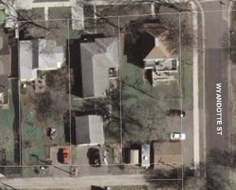
Figure 15. Residential Setbacks. The center home above makes good use of the lot by setting the home off to one side, placing the garage in the rear of the home—accessible from the alley. The home and the garage are each 20’ from the front and rear property lines respectively. The 15’ on the west side of the house would be sufficient for a driveway if the alley was not available. The lot is 50’ x 150’.
(2) Front Yards.
(a) Front setbacks for SFR uses should be sufficient to preserve privacy yet encourage interaction with pedestrian traffic. In general, setbacks should be no more than 20 feet from the property line.
(b) No structure shall be allowed in the public right-of-way or within an intersection sight triangle, as defined in Article 2 of the Zoning regulations, or as to otherwise restrict the line of sight for motorists on a public street or alley.
(3) Side Setbacks.
(a) If a multi-family, mixed-use or commercial use adjoins a single-family residential use, the side setback for the new or renovated structure shall be a minimum of five feet for building height up to 12’0”, plus one foot for every 10 feet of building height measured in whole foot increments of side yard setback (see Table 1 below).
|
Building
Height |
Setback |
|
0
to 12’0” |
5’ |
|
12’1” to
22’0” |
6’ |
|
22’1” to
32’0” |
7’ |
|
32’1” to
42’0” |
8’ |
|
42’0” to
52’0” |
9’ |
|
52’0” to
62’0” |
10’ |
Table 1
(b) For fire safety and general access purposes, for any structures that do not share a common wall, there must be a minimum structure separation distance of 10 feet, regardless of the structure’s position relating to property lines. Adjacent structures, whether on the same lot or tract or not, shall be allowed to abut, providing that all appropriate fire and building code requirements are met.
(4) Rear Setbacks.
(a) Rear setbacks should be sufficient to provide a private recreational (yard) space for SFR or MFR uses.
(b) Commercial and mixed-use structures (including those with residential uses) may observe a zero lot line unless abutting a SFR or MFR use, then the commercial or mixed-use site shall observe a minimum 10’ rear setback.
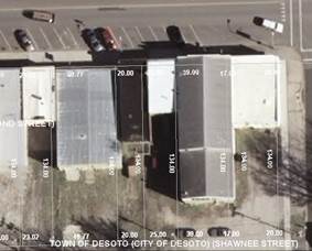
Figure 16 Commercial Setbacks. Commercial buildings typically do not observe side setbacks and often have shared side walls. The rear of the lot can then be used for storage, parking and deliveries.
7. Bulk Requirements. The scale of new and redeveloped structures may be approved with the site plan where sufficient evidence shows that the structure will blend in with the neighborhood through use of step-backs, elevations articulation, similar structural elements and/or use of alternative structural examples from the same architectural or historical period. For example, in the early 1900’s two-story buildings were often located at or near prominent intersections, using the lower level for commercial/retail space and upper levels for offices or residential. Although a two-story building may be out of scale for the location, it would still be within the historical character of the neighborhood.
8. Parking Guidelines.
A. For commercial development, and in locations where parking is available on the street, off-street parking requirements for new projects and renovations on sites that are a single lot/tract or less than one acre may be reduced by as much as 50% of the number required by Article 6 Off Street parking and Loading Regulations.
B. For either residential or commercial development, parking and garages shall be located in the rear yard area.
C. Where alleys are available, parking and garages shall be accessed from an alley.
9. Landscaping and Buffering. A landscape plan shall be submitted with the application that meets the regulations set forth in Article 8, Landscaping and Buffering. The Planning Commission shall have the ability to reduce the total landscaping requirements up to 70% when reviewing the application, based upon the specific needs of the individual site and its surrounding area.
10. Drainage. The requirements of Article 6—”Improvements Dedications & Design” of the Subdivision Regulations, as well as the requirements of Section 5600 of the Kansas City Chapter of the American Public Works Association shall apply to all “UDO” Uptown De Soto Overlay District developments, with the following exception:
A. The stormwater detention requirements may be waived, upon determination by the City Engineer that any increased runoff from the proposed development will not cause undue harm to downstream properties, or overload any downstream stormwater conveyance elements. At the discretion of the City Engineer, the applicant may be required to submit a drainage study quantifying the development’s potential impacts to downstream areas.
11. Administration.
A. The approved site plan may be amended by following the same procedure as set forth above for the original plan.
B. Building permits may only be issued for the improvements specified in the approved site plan.